Travel: Newfoundland
2026-07-02
After my earlier trip to Europe, I realized that I wanted to keep seeing more new things before starting my new position. I landed on Newfoundland, likely because it’s been a particular focal point for my relatives. I wanted to see Gros Morne National Park, which is a UNESCO World Heritage Site.
I decided that I wanted to get some hiking in, try kayaking, and see more of rural Newfoundland. So, with a friend of mine, I booked for late June and paid a hefty sum for a rental car.
On the first day, we drove from Gander to Deer Lake – about a 3 hour drive in our experience. Driving on Route 1 is interesting. Unlike Ontario drivers, Newfoundland drivers really do not seem to speed very much. I suspect that this could be a result of wanting to avoid plowing into a moose, but I don’t know for certain.
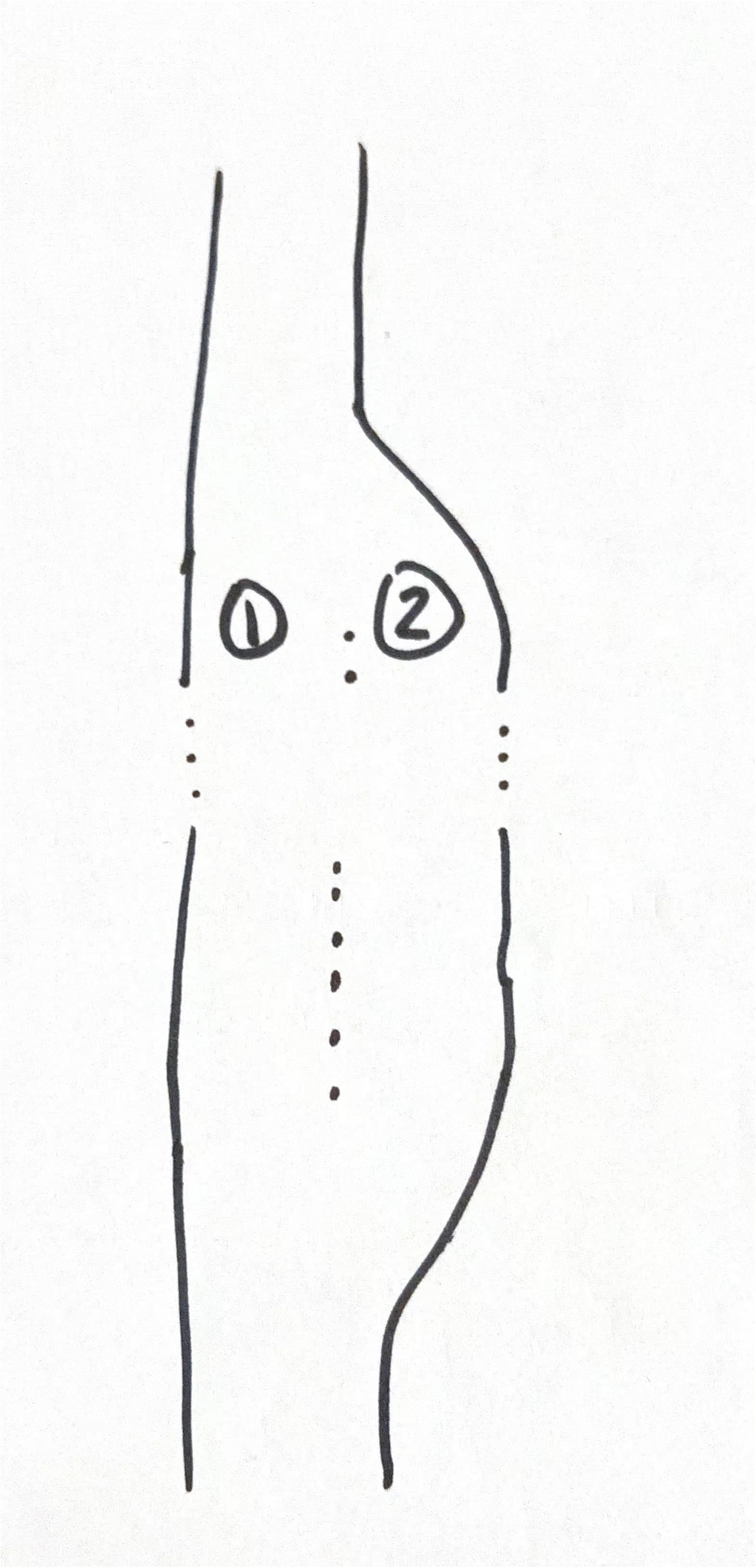
Route 1 also has one feature I consider interesting: its passing lanes. I suspect that avoiding using excess road space (which entails more maintenance and an increased budget) kind of necessitates building the kind of lanes as below.
The further right lane is the non-passing lane, leaving people who want to pass to continue straight and complete a pass before the end of the lane. As cars approach positions 1 and 2, the car in position 1 must yield to the one in position 2.
From Deer Lake, we woke early to head to Norris Point, a town of just about 600 people. At Gros Morne Adventures, we did a kayak tour for 4.5 hours in total. One highlight was seeing a Bald Eagle. Americans are lying. The bird does not actually sound that cool normally. It makes funny chirps. The earth there looked as if you’d removed layers of it and put it on its side. Our guide explained that this was from isostatic rebound. Such a process is the rise of land masses after ice sheets from the last ice glacial period melted.
I really recommend the tour. Per person, I think it was about 180 Canadian, which was more than fair for the surety of having a guide and the informative content. After that, we headed to Berry Hill, one of the five campgrounds in Gros Morne National park. It was pretty good. Network connection is spotty, but where isn’t in Newfoundland? The visitor centre at the entrance of the park is pretty good as well.
We did several hikes within Gros Morne National Park while at Berry Hill. I recommend going to the Tablelands, but probably not following the unmarked trail that leads you to the top of the Tablelands. It’s probably a bit steep, but the weather conditions in late June were pretty poor at the base and top of the mountain were dramatically worse. After reaching the bottom, my friend and I decided we were done with unmarked trails.
The Tablelands is one of a few spots where the mantle of the Earth is exposed via tectonic events. The rocks are really Mars esque and the water running down it is basic to the point of being a health hazard to those who consume it.
Following our debacle with the Tablelands, we drove up Route 430 (also known as the Viking Trail). In the town of Cow Head, we saw a cool fabric ars store called Skivvers where you can buy yarn, crochet hooks, knitting needles, crafts, and other related items. We then stopped to camp in Pistolet Bay Provincial Park, nearer to St. Anthony. Pistolet Bay was smaller and nicer than Berry Hill. I found that generally the sites were less populated and the washrooms cleaner. Highly recommended to stay there. St. Anthony has a lot of good places to see icebergs, and one of the only places that I saw tofu aside from Deer Lake’s Foodland.
We stopped to see L’Anse aux Meadows, which is just fantastic. I highly recommend going there. If inclined, I might write a follow up post kind of summarizing all of the things I learned there.
From there, we headed to Shallow Bay, a campground inside Gros Morne National Park. It’s situation at one of Newfoundland’s few sand beaches. Given the weather, I didn’t want to swim, but a nice man from New Brunswick told me about Merlin, which is a fun app to identify birds.
We decided to go see the Green Gardens Trail, which was a good change of pace. I found it pretty easy to do and very well marked. One thing we didn’t see was the sea caves, which I suspect might have been just unobvious to get to. We noted that there were (wild?) sheep that had left behind tufts of their wool on the trail. As we climbed back up to the trailhead, the fog cleared and I got some really great photos.
On the penultimate day of the trip, we decided to go to Sir Richard Squires provincial park because it would shave off an hour from the time it takes to drive to Gander. Sir Richard Squires is a good park, but somewhat isolated by a drive over a gravel road to get there.
The aforementioned Route 1 can tend to have construction on it. Given that it is, for most of its duration, a two lane highway, one should assume that delays are possible if they are coming from western Newfoundland to fly from Gander.